Deprivation


Deprivation is deeply entrenched in Walsall and had worsened during the recession. Key facts are:

  1. 44 out of 167 neighbourhoods (LSOAs) are now amongst the most deprived 10% in England compared to 34 in 2015.
  2. The 2019 Index of Multiple Deprivation now ranks Walsall as the 25th most deprived English local authority (out of 317), placing Walsall within the most deprived 10% of districts in the country (33rd in 2015, 30th in 2010 and 45th in 2007).
  3. There are extremes of deprivation, with central and western areas typically much more deprived than eastern areas, although pockets of deprivation exist even in the more affluent parts of the borough.
  4. Walsall fares particularly badly in terms of income (16th), education, skills & training deprivation (11th)  and employment (38th) and many of the issues that challenge the borough match the geography of deprivation.
  5. The high and increasing levels of child poverty puts additional demands on services. Walsall ranks 17th for income deprivation affecting children index (IDACI 2019) with the Borough’s relative deprivation increasing over time (27th in 2015).
  6. 1 in 3 (29.9%) aged under 16 years are living in low income families, higher than the national average of 20.1% (HMRC, 2016).
  7. By the end of January 2017, 20.8% of primary school pupils were entitled to free school meals compared to the national average of 14.5% and 19.1% of secondary school pupils compared to 13.2% nationally (DfE June 2016).

Image of, and link to, Walsall's 2019 deprivation report

Indices of Multiple Deprivation 2019 Report

The latest IMD report contains a full analysis of deprivation across the Walsall Borough.

Deprivation Dashboard


The following dashboard allows you to explore deprivation across Walsall by postcode, ward, locality & lower super output area, across each of the domains by year.

Deprivation by Urban Areas


The following map displays deprivation by urban area. Areas of blank space are largely rural areas where there are few buildings, such as parks and greenspace. Viewing deprivation in this manner highlights the discrepancy between the eastern and western halves of the borough. The east contains fewer urban areas, and therefore comprises a smaller population living in relatively low deprivation. The west, however, features far less open-space, houses the bulk of Walsall's population and is highly deprived.

Deprivation by urban areas in Walsall, where red indicates areas of high deprivation and blue indicates low deprivation.

Deprivation Maps

The following map displays the geographical picture of deprivation across the Walsall borough, ranked against England as a whole. The colour shaded LSOAs (Lower-layer Super Output Areas) rank the most deprived as red & least as green. For instance, we can see that Area E (Blakenall) has a high proportion of the most deprived LSOAs in England, whereas parts of Aldridge & Streetly feature the least. It shows a very diverse picture, with east & west radically different from one another.

Walsall deprivation map indicating extremes: high deprivation (deciles 1 and 2 in red and orange) versus low deprivation (deciles 9 and 10 shaded in green).

The following map groups the LSOAs into quintiles ranking them from most to least deprived. This also displays the gulf in deprivation geographically, between east & west.

Walsall deprivation map that is colour gradated by quintile (1 to 5, most to least deprived areas)

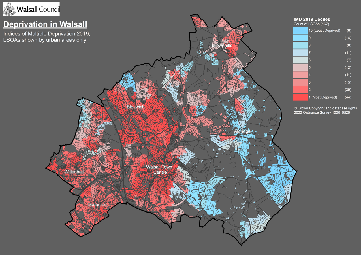
Data source: Indices Multiple Deprivation 2019Ministry of Housing, Communities & Local Government